

SWIRE is a wide-area, high galactic latitude, imaging survey to trace the evolution of dusty, star-forming galaxies, evolved stellar populations, and active galactic nuclei as a function of environment from redshifts, z ~ 3, when the Universe was about 2 billion years old, to the present time. SWIRE will survey approximately 70 square degrees with the MIPS far-infrared camera and the with the IRAC mid-infrared camera. The key scientific goals of SWIRE are to determine:
 ); up to 40,000 with z > 2.
(2) 1 million early-type galaxies; up to 400,000 with z > 2.
(3) 30,000 classical AGN, and as many as 250,000 dust-obscured QSO/AGN.
); up to 40,000 with z > 2.
(2) 1 million early-type galaxies; up to 400,000 with z > 2.
(3) 30,000 classical AGN, and as many as 250,000 dust-obscured QSO/AGN.
The satellite data will be complemented by an extensive program of ground-based optical, near-infrared and radio observations, providing identifications, photometric-redshifts, spectral energy distributions and other physical information. All of the survey data will be available to the Astronomical Community through the NASA/IPAC Infrared Science Archive.
Please note Survey changes for 2003 August launch, most especially XMM-LSS coordinate change. Even though SIRTF has now launched, all information on this page is still subject to change and should be considered tentative! If you are making detailed plans based on the SWIRE survey, it would be safest to contact the science team to confirm the details.
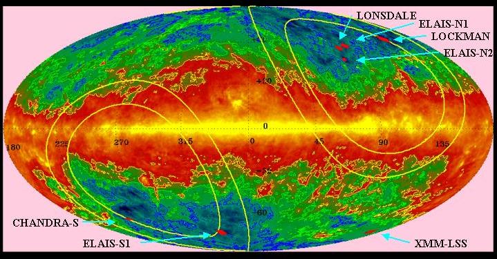
SWIRE will survey approximately 65 square degrees distributed over 7 fields in the northern and southern sky, which will enable follow-up with many existing ground and space telescope facilities.
The SWIRE Team has performed an exhaustive search for high-latitude fields with low-background to maximize the sensitivity of the SWIRE Legacy Survey. The fields below represent, in many respects the largest, lowest infrared background regions in the sky. The selection criteria were:
 < 0.5 MJy/SR)
in order to minimize
confusion and noise.
< 0.5 MJy/SR)
in order to minimize
confusion and noise.
Survey Areas:
Survey fields reflect AORs effective as of Aug 2003 launch. Images show IRAC/MIPS fields for plausible observation dates within SWIRE requested timing constraints, but remain subject to the uncertainties of spacecraft scheduling.
| Field | Center (J2000) | Area | Primary Window | P.A. | Background | Program ID | |||
|---|---|---|---|---|---|---|---|---|---|
| RA | DEC | MIPS | IRAC | Start | End | (°E of N) | (MJy/Sr) | ||
| ELAIS S1 - images | 00h 38m 30s | -44° 00' | 14.56 | 2004 Jun 10 | 2004 Jul 23 | 156-177° | 0.42 | SWIRES_ELAIS_S1 | |
| XMM-LSS - images | 02h 21m 20s | -04° 30' | 9.18 | 2004 Jul 17 | 2004 Aug 28 | 156-170° | 1.3 | SWIRES_XMM_LSS | |
| Chandra-S - images | 03h 32m 00s | -28° 16' | 7.83 | 2004 Aug 15 | 2004 Sep 10 | 165-185° | 0.46 | SWIRES_CHANDRA_S | |
| Lockman Field - images | 10h 45m 00s | +58° 00' | 14.40 | 2004 Apr 23 | 2004 May 23 | 45-24° | 0.38 | SWIRES_LOCKMAN | |
| Lonsdale Field - images | 14h 41m 00s | +59° 25' | 6.93 | 2004 Jan 31 | 2004 Feb 21 | 191-170° | 0.47 | SWIRES_LONSDALE | |
| ELAIS N1 - images | 16h 11m 00s | +55° 00' | 9.18 | 2003 Dec 15 | 2004 Jan 20 | 255-220° | 0.44 | SWIRES_ELAIS_N1 | |
| ELAIS N2 - images | 16h 36m 48s | +41° 01' 45" | 4.66 | 2004 Jun 19 | 2004 Jul 23 | 76-43° | 0.42 | SWIRES_ELAIS_N2 | |